Kunanyi / Mount Wellington Hobart: The Complete Visitor Guide (2026)
Kunanyi / Mount Wellington rises 1,271 metres directly behind Hobart's CBD on the western side of the city. It takes approximately 30 minutes to drive from the city centre to the Pinnacle. The mountain's Aboriginal name, kunanyi, comes from the palawa kani language and has been officially recognised alongside Mount Wellington since 2013. Walking tracks begin at Fern Tree, about 15 minutes from central Hobart. The summit is 10°C cooler than the CBD on any given day bring a layer regardless of the season.
On a clear Hobart morning, you can see the mountain from almost anywhere in the city. It rises steeply from the western edge of the suburbs, its dolerite columns darkening as cloud gathers around the Pinnacle, its upper slopes still carrying snow into October. kunanyi, as the palawa people have called it for tens of thousands of years, is the most obvious thing about Hobart and the most underestimated one. Most visitors glance at it, think about going, and run out of time.
The ones who do make the trip up whether they drive to the Pinnacle, walk from Fern Tree, or catch a sunrise from the summit shelter tend to agree that it belongs on the shortlist of genuinely memorable things they did in Tasmania. Not because it is difficult, but because the view from 1,271 metres changes the way you understand the place you have been spending time in. Hobart looks small from up there. The Derwent River curves toward the sea. The peninsula stretches south toward Antarctica. The scale shifts.
This guide covers everything you need to visit kunanyi / Mount Wellington: the mountain's history, how to get there, every walking track worth knowing about, what to expect at the summit in each season, and which Island Collective properties sit closest to the Fern Tree trailhead.
What is kunanyi / Mount Wellington?
kunanyi is a 1,271-metre peak on the western edge of Hobart, in the state of Tasmania. It is the highest point in the greater Hobart region and forms the western boundary of the city, visible from the waterfront, from Salamanca Place, and from most of the inner suburbs on any clear day.
The mountain has been known as kunanyi by the palawa people of Tasmania for millennia. The word comes from palawa kani, the reconstructed language of Tasmanian Aboriginal people, and carries cultural significance that predates European settlement by tens of thousands of years. In 2013, the Tasmanian government formally recognised the dual name kunanyi/Mount Wellington the first mountain in Australia to receive official dual naming at the state level. Today, both names are in common use and both appear on official signage.
European settlers named it Mount Wellington in 1829, after Arthur Wellesley, the first Duke of Wellington, following his victory at the Battle of Waterloo. The mountain had been mapped by earlier explorers under different names, but Wellington is the European name that stuck.
The mountain is part of Wellington Park, a 18,000-hectare conservation area that stretches west of Hobart. Driving into it from the suburban streets of South Hobart or Fern Tree, the transition is immediate: native bush, clear mountain air, and a silence that the city below seems to forget about entirely.
How tall is kunanyi / Mount Wellington?
kunanyi / Mount Wellington stands 1,271 metres (4,170 feet) above sea level. For context, that is higher than any point in the Australian Alps that lie within 200 kilometres of a major city. On a clear winter day, the Pinnacle carries snow while Hobart's waterfront, 12 kilometres to the east and 1,259 metres below, sits in mild sunshine.
The summit temperature runs approximately 10 degrees Celsius cooler than the Hobart city centre on any given day. In winter, this means the Pinnacle can sit at minus five or lower while the CBD is a comfortable 10 degrees. In summer, the city might reach 28 degrees while the summit stays at a refreshing 18. Always carry an extra layer regardless of the weather at accommodation level. The mountain has its own climate and it can change within the hour.
| Quick fact | Detail | What this means for visitors |
|---|---|---|
| Height | 1,271 metres (4,170 feet) | Highest point in the greater Hobart region |
| Aboriginal name | kunanyi (palawa kani language) | Officially recognised alongside Mount Wellington since 2013 |
| European name origin | Named after the Duke of Wellington, 1829 | The mountain had been known to palawa people for tens of thousands of years |
| Distance from CBD | 12 kilometres west of Hobart | 30-minute drive to the Pinnacle via Pinnacle Road |
| Summit temperature | Approximately 10°C cooler than Hobart | Always bring a warm layer regardless of CBD weather |
| Snow season | June through September typically | Snow at summit is common - chains occasionally required on Pinnacle Road |
| Pinnacle Road | Open year-round when conditions allow | Road closes in severe weather - check Parks Tasmania before driving |
| Walking tracks | 10-plus marked trails | Range from easy foreshore walks to challenging summit routes |
| Conservation area | Wellington Park | Protected area - no fires, pets restricted, leave no trace |
How to get to kunanyi / Mount Wellington from Hobart
There are two ways to reach the mountain: drive or walk. Most visitors do both drive up on the first day to see the summit views and understand the scale, then walk from Fern Tree on a separate morning.
Driving to the Pinnacle
The Pinnacle Road begins in the Hobart suburb of Fern Tree and winds up through native bush and alpine vegetation for approximately 13 kilometres to the summit car park. The drive takes about 20 minutes from Fern Tree and 30 minutes from the Hobart CBD. The road is sealed the entire way and suitable for all standard passenger vehicles in normal conditions.
In winter, snow and ice can make the upper sections of Pinnacle Road impassable. Parks Tasmania closes the road when conditions require it. Check the Parks Tasmania website or call the hotline on the morning of your visit if there has been recent rain or overnight frost at high altitude. Chains are occasionally required and rental outlets in Hobart stock them.
Getting there by bus or tour
Metro Tasmania runs bus services to Fern Tree, at the base of the mountain, from the Hobart CBD. From Fern Tree, you walk to the summit via the Pinnacle Track. Several Hobart tour operators run guided summit tours that include transport and commentary. It is a good option for guests who want context without the logistics of driving.
Walking tracks on kunanyi / Mount Wellington
The mountain has more than ten marked walking tracks, ranging from a flat 45-minute family loop near The Springs to a demanding 7.5-kilometre summit climb. Here is a full guide to the main tracks:
| Walk name | Start point | Distance | Time | Grade | Notes |
|---|---|---|---|---|---|
| Pinnacle Track | Fern Tree | 7.5km | 4–5 hrs | Hard | The classic summit route - most rewarding, most demanding |
| Organ Pipes Track | The Springs | 4.2km | 2–3 hrs | Moderate | Views of the distinctive dolerite columns - shorter alternative |
| Pipeline Track | Fern Tree | 9.6km | 2–3 hrs | Easy | Flat and scenic - popular with trail runners and cyclists |
| Chalet Track | The Springs | 3.0km | 1–2 hrs | Moderate | Links Springs to Pinnacle Road - good as part of a longer loop |
| Radford Track | Fern Tree | 5.6km | 2–3 hrs | Moderate | Less crowded than Pinnacle Track - quieter summit approach |
| Lenah Valley Track | Lenah Valley | 8.0km | 4–5 hrs | Hard | Long and remote feeling - best for experienced walkers |
| Panorama Track | The Springs | 2.0km | 45 mins | Easy | Short loop near Springs with good valley views - suits families |
The Pinnacle Track from Fern Tree is the route most visitors mean when they say they walked Mount Wellington. It climbs 900 vertical metres over 7.5 kilometres and typically takes four to five hours return. The track is well-marked but exposed in the upper sections appropriate footwear and warm layers are essential. The reward at the summit is the full 360-degree panorama across Hobart, the Derwent estuary, and the Tasmanian wilderness to the west.
For a full step-by-step guide to the Fern Tree to Pinnacle route including what to bring, where to stop, and how to prepare, read our dedicated Mount Wellington walk from Fern Tree guide.
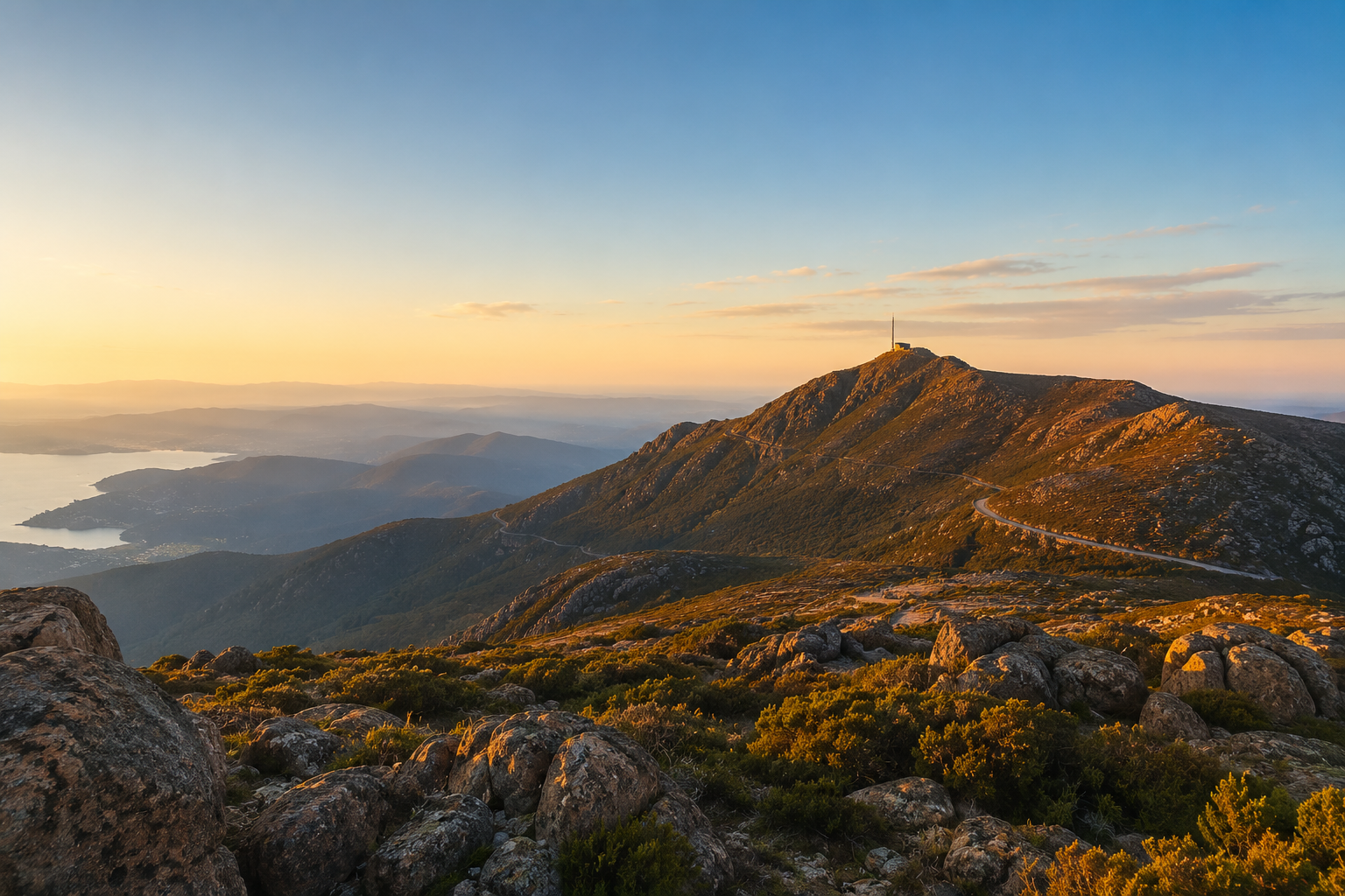
What to expect at the summit of kunanyi / Mount Wellington
The Pinnacle Observatory Shelter sits at the summit and was built in 1937. It provides shelter from the wind and contains basic facilities. The Organ Pipes is a dramatic series of vertical dolerite columns on the mountain's southern face are visible from the summit and from the upper sections of the Pinnacle Track. They are one of the most distinctive geological features in Tasmania and worth taking time to observe from the shelter lookout.
On a clear day, the summit view extends up to 100 kilometres in every direction. To the east, Hobart's grid of streets runs down to the Derwent River. The Tasman Peninsula extends south toward Cape Raoul. The Central Plateau stretches north and west into the interior of the island. On the best days, the islands of the Huon and D'Entrecasteaux Channel are visible to the south.
Cloud is the variable to plan around. The Pinnacle sits at summit level for approximately 60 percent of the year, meaning many visits see the shelter enveloped in low cloud with limited visibility. Check the Bureau of Meteorology forecast for the Pinnacle specifically not just Hobart CBD before committing to a summit walk or drive.
| Season | Months | What to expect | Visitor tip |
|---|---|---|---|
| Summer | Dec to Feb | Clear summit days, wildflowers on upper slopes | Crowds peak in January. Start walks before 9am to avoid heat at lower elevations |
| Autumn | Mar to May | Best visibility of the year, cool and still | Arguably the best season for walking - stable weather, lower crowds, golden light |
| Winter | Jun to Aug | Snow on summit, dramatic cloud formations | Pinnacle Road may close - check before driving. Summit walks require cold-weather gear |
| Spring | Sep to Nov | Wildflowers return, waterfalls running strong | Weather is unpredictable - snow one day, sunshine the next. Rewarding if prepared |
What to bring to kunanyi / Mount Wellington
The mountain's temperature variation and unpredictable weather make preparation more important than the 30-minute drive from the city might suggest. Bring these regardless of the season:
• Warm mid-layer and waterproof outer shell - the summit is 10°C cooler than the CBD and wind chill can make it feel colder. A light down jacket and rain jacket cover most conditions.
• Sturdy footwear - for any walk beyond the car park, proper hiking shoes or trail runners with grip are essential. Smooth-soled shoes on dolerite rock and wet track surfaces are a genuine hazard.
• Water and snacks - there are no food facilities on the mountain outside the car park area. Carry at least one litre of water per person for any walk longer than the Panorama Track.
• Fully charged phone - for navigation, the Bureau of Meteorology weather app, and emergency contact if conditions change unexpectedly.
• Sun protection - at altitude, UV exposure increases significantly even on cool days. Sunscreen, sunglasses, and a hat are relevant even in winter.
• Cash or card for parking - the Pinnacle summit car park has a fee. Check current rates on the Parks Tasmania website before driving up.
Where to stay near kunanyi / Mount Wellington in Hobart
The closest base for a Fern Tree trailhead start is Sandy Bay, which puts you 8 minutes from the main walking tracks. The Island Collective operates two properties there:
| Property | Location | To Fern Tree | Why it works for a mountain trip | Book |
|---|---|---|---|---|
| The Tempo | Sandy Bay | 8-min drive to Fern Tree | Closest Island Collective property to the main trailhead. Private outdoor hot tub for post-walk recovery. | View |
| The Helm | Sandy Bay | 8-min drive to Fern Tree | Same Fern Tree access as The Tempo. Coastal setting with outdoor hot tub under open sky. | View |
| The District | Hobart CBD | 15-min drive to Fern Tree | CBD access for restaurants and Salamanca. Slightly further from trailhead but excellent for multi-day trips. | View |
| The Royale | Hobart CBD | 15-min drive to Fern Tree | Heritage CBD setting. Good base for guests combining a mountain day with waterfront dining. | View |
The Tempo and The Helm in Sandy Bay sit 8 minutes from the Fern Tree trailhead close enough to leave before dawn for a sunrise walk and return for breakfast in your own kitchen. Both have private outdoor hot tubs that earn their keep after a long day on the mountain. Stepping from cold alpine air into a heated outdoor spa at the end of a Pinnacle Track return is the kind of contrast that makes a Hobart trip genuinely memorable.
For a full guide to staying in Sandy Bay and everything the suburb offers beyond the mountain, read our Sandy Bay accommodation guide.
Frequently Asked Questions
How tall is kunanyi / Mount Wellington?
kunanyi / Mount Wellington stands 1,271 metres (4,170 feet) above sea level. It is the highest point in the greater Hobart region and sits approximately 12 kilometres west of the Hobart city centre. The summit runs about 10 degrees Celsius cooler than the CBD on any given day.
What does kunanyi mean and why does Mount Wellington have two names?
kunanyi is the name used by the palawa people of Tasmania for the mountain, drawn from the palawa kani language, the reconstructed language of Tasmanian Aboriginal people. The name has been in use for tens of thousands of years. Mount Wellington was the name given by European settlers in 1829. In 2013, the Tasmanian government formally recognised both names, making kunanyi/Mount Wellington the first officially dual-named mountain in Australia.
How do you get to the top of Mount Wellington from Hobart?
You can drive or walk. Driving via Pinnacle Road takes approximately 30 minutes from the Hobart CBD and the road is sealed all the way to the summit car park. Walking the Pinnacle Track from Fern Tree takes four to five hours return and covers 7.5 kilometres with 900 metres of vertical gain. Fern Tree is about 15 minutes from the CBD by car. Bus services from the CBD also run to Fern Tree.
What is the best walk on Mount Wellington for beginners?
The Panorama Track near The Springs is the most accessible option for beginners. A two-kilometre loop taking about 45 minutes with modest elevation gain and good valley views. For a more rewarding walk with manageable difficulty, the Organ Pipes Track from The Springs (4.2km, two to three hours return) offers views of the mountain's distinctive dolerite columns without the full commitment of the Pinnacle Track.
Is Mount Wellington open in winter?
Yes, though access to the Pinnacle Road can be restricted by snow and ice between June and September. Parks Tasmania closes the road when conditions make it unsafe for vehicles. Snow at the summit is common during this period. Walking tracks remain accessible in most winter conditions, but the upper sections of the Pinnacle Track require appropriate cold-weather gear. Always check the Parks Tasmania website or hotline before heading up in winter.
Where is the best accommodation near Mount Wellington?
The closest Island Collective properties to the Fern Tree trailhead are The Tempo and The Helm in Sandy Bay both an 8-minute drive from the main walking tracks. Both include private outdoor hot tubs, which work particularly well after a long day on the mountain. The District and The Royale in the Hobart CBD are 15 minutes from Fern Tree and suit guests combining a mountain day with waterfront dining and Salamanca. Book direct at theislandcollective.com.au.
Staying in Hobart for your kunanyi adventure?
The Tempo and The Helm in Sandy Bay are 8 minutes from the Fern Tree trailhead with a private outdoor hot tub waiting when you return. Browse and book direct at theislandcollective.com.au.
No platform fees. Best rate guaranteed.